The San Francisco Bay is an irreplaceable gift of nature that man can either abuse and ultimately destroy-or improve and protect for future generations. The Bay Plan presented in this report recognizes that the Bay is a single body of water, in which changes affecting one part may also affect other parts, and that only … Continue reading “San Francisco Bay Plan”
The Delta Plan is a comprehensive, long-term management plan for the Delta. Required by the 2009 Delta Reform Act, it creates new rules and recommendations to further the state’s coequal goals for the Delta: Improve statewide water supply reliability, and protect and restore a vibrant and healthy Delta ecosystem, all in a manner that preserves, … Continue reading “The Delta Plan”
“Bay Delta Plan” is short for the State Water Resources Control Board’s (State Water Board) San Francisco Bay/Sacramento-San Joaquin Delta Estuary Water Quality Control Plan. The Bay-Delta Plan identifies the beneficial uses of the Bay-Delta, water quality objectives for the reasonable protection of those beneficial uses, and a program of implementation for achieving the objectives. … Continue reading “Bay Delta Water Quality Control Plan (Bay Delta Plan)”
Environmental flows are gaining broad recognition across the United States, and the underlying science is sufficiently developed to support regional planning and policy applications. This report explores how six states and three interstate river basins are effectively developing and applying regionalized environmental flow criteria to water resource planning, water withdrawal permitting, and multi-dam re-operation. The … Continue reading “A practical guide to environmental flows for policy and planning (with 9 case studies)”
The water years of 2012-14 stand as California’s driest three consecutive years in terms of statewide precipitation, and as of this writing in February 2015 the drought is continuing on. This report was prepared to compare the hydrology and impacts experienced during 2012-2014 with those of California’s largest historical droughts, in response to questions from … Continue reading “California’s most significant droughts: Comparing historical and recent conditions”
Over the past 30 years the Australian state of Victoria developed innovative approaches to planning and setting priorities for environmental water, along with new tools to manage it. These sweeping reforms were in part a response to the Millennium Drought, a decade-long record dry spell that severely affected all water use in Victoria. California—currently in … Continue reading “Managing Water for the Environment During Drought: Lessons from Victoria, Australia”
Droughts are a recurring feature of California’s climate. Major droughts provide an opportunity to review management responses and derive policy lessons that can better prepare society for the next one. Here we take stock of how California’s cities and suburbs have responded to recent droughts, review the state’s evolving role in urban drought management, and … Continue reading “Building Drought Resilience in California’s Cities and Suburbs”
With rising sea levels and the increased likelihood of extreme weather events, it is important for regional agencies and local municipalities in the San Francisco Bay Area to have a clear understanding of the status, composition, condition, and elevation of our current Bay shore, including both natural features and built infrastructure. The purpose of this … Continue reading “San Francisco Bay Shore Inventory Mapping for Sea Level Rise Planning”
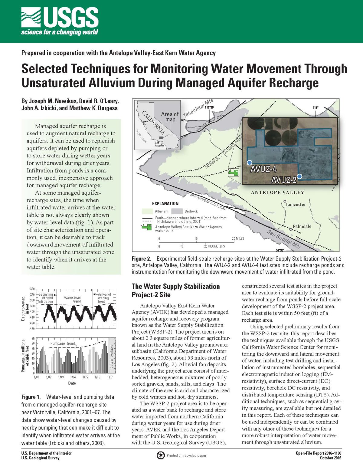
Managed aquifer recharge is used to augment natural recharge to aquifers. It can be used to replenish aquifers depleted by pumping or to store water during wetter years for withdrawal during drier years. Infiltration from ponds is a commonly used, inexpensive approach for managed aquifer recharge. At some managed aquifer recharge sites, the time when … Continue reading “Selected Techniques for Monitoring Water Movement Through Unsaturated Alluvium During Managed Aquifer Recharge”
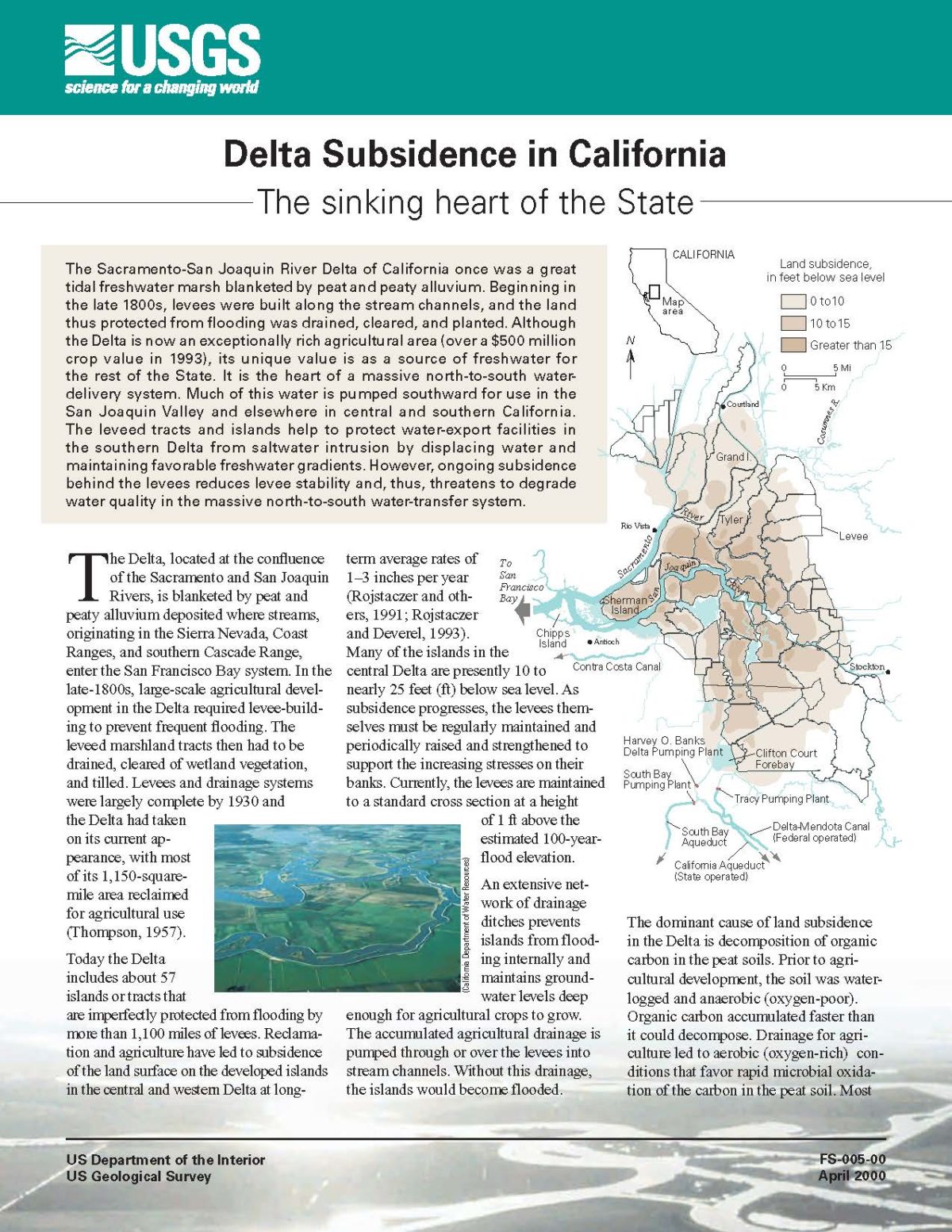
The Sacramento-San Joaquin River Delta of California once was a great tidal freshwater marsh blanketed by peat and peaty alluvium. Beginning in the late 1800s, levees were built along the stream channels, and the land thus protected from flooding was drained, cleared, and planted. Although the Delta is now an exceptionally rich agricultural area (over … Continue reading “Delta Subsidence in California: The sinking heart of the state”