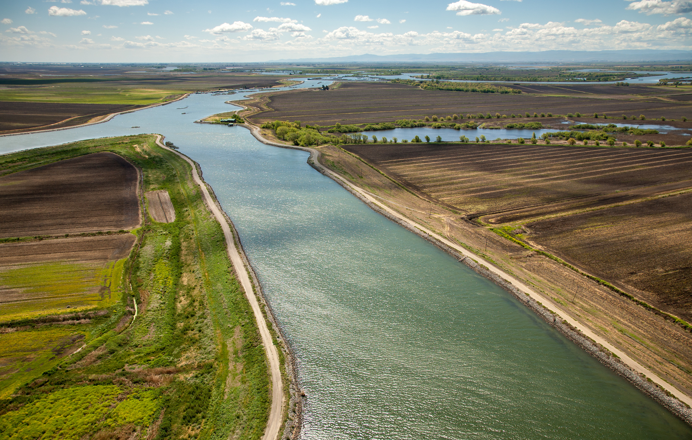
New intakes to convey Sacramento River south could be placed on the reach near Hood.
Photo: Kelly Grow, Cal Department of Water Resources
A Century of Delta Conveyance Plans
By John Hart
Introduction
The Peripheral Canal. Duke’s Ditch. The Biemond Plan. Jerry Brown’s two tunnels. Gavin Newsom’s one. Sometimes it seems that California water debates revolve around a single question: how best to shift water from the Sacramento River, across, around or under the Sacramento-San Joaquin Delta, to farms and cities to the south and west.
This focus is too intense. Water moved in this manner makes up, on average, no more than a tenth of California’s developed water supply, and this proportion is decreasing. Yet there are reasons why we can’t take our eyes off the Delta. Some regions do depend quite heavily on this water. Feeling our way through a thicket of numbers, we can say that the Bay Area, the San Joaquin Valley, and metropolitan Southern California each get as much as a third of their supply via pumps at the Delta’s southern edge.1 The cross-Delta transfer still dwarfs any other single artificial movement of water in the state, and it is the link that binds the vast majority of the state’s water systems into an interconnected, though imperfectly integrated, whole.
Two great, intertwined, and unsolved questions haunt this north-south transfer. The first is how large it should be. This issue nests inside a larger one: how much of the natural flow from the Central Valley watershed should still be allowed to follow its old route down various channels in the Sacramento-San Joaquin River Delta to Suisun Bay, San Pablo Bay, and San Francisco Bay? The debate used to be framed as an economic contest between the thirsts of a single Bay Area County, Contra Costa, and those of San Joaquin Valley and metropolitan southern California. It is now seen much more in environmental terms. But almost one hundred years after it was first asked, this question is still in search of an answer.
The second question is by what route the water sent southward should travel. A rare point of agreement is that the present arrangement is not satisfactory. Water entering the Delta at the north exits at the southwest corner, drawn that way by three great arrays of pumps near Tracy, two serving the federal Central Valley Project and the third belonging to the State Water Project. These flows cut across natural seaward ones, causing water in many channels to run backwards at times. Plankton, eggs, and small fish vanish into the intakes; many larger fish die in the works despite inadequate fish screens. Accelerated currents erode banks and hurry nutrients out of useful reach. The ill effects on salmon and other species—on an entire ecosystem—are well known, compounding the damage done by the sheer volume withdrawn.2 Efforts to alter this Rube Goldberg system have, one after another, died in controversy, due in essence to fears that improved engineering would lead to greater exports and lower outflows. This year the state offers a new, scaled-down plan.
Understanding outflows
Cross-Delta conveyance has to be seen in the context of overall water movements. A second paper will focus on the vexed question of Delta outflows, but here is a very brief sketch.
In our variable climate (and becoming more so), the amount of runoff to the Delta and the Bay fluctuates wildly from year to year. That is one reason we have our elaborate water systems. Reservoirs are time machines, shifting supply from wet seasons to dry and from soggy years to arid ones. In very wet years, what is called the “unimpaired” flow from the Delta into the Bay would exceed 50 million acre-feet (MAF). In very dry ones, it could be under 10 MAF.3
The human draw varies too, but within a much smaller range. It includes water that people consume in the watershed before it can reach the Delta; water the Bay Area pipes in directly from the Mokelumne and Tuolumne Rivers, bypassing the Delta; water used in the Delta itself; and Sacramento River water drawn through and out of the Delta for shipment mostly southward (but serving additional swathes of the Bay Area). The combined draw has recently fluctuated around 12 MAF. In very wet years, that leaves a great deal of water to flow toward the Golden Gate; in very dry years, outflows drop to mandated minimum levels of about 10 MAF.4
All images click to enlarge
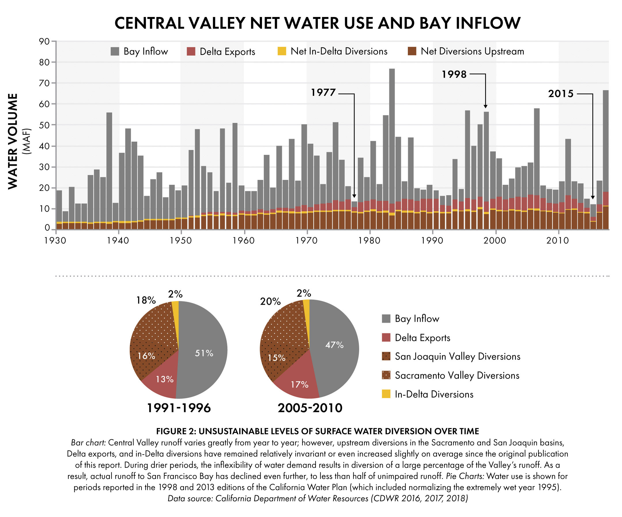
The amount taken directly from the Delta for export—the amount that passes through “Delta conveyance”—is not the largest slice of the pie chart, but it is the slice that has shown the greatest growth. It was zero in 1950 and reached 6.4 MAF in 2006, a level unlikely to be reached again.5 The proportion exported via the pumps grew from 15% in the 1970s and 1980s to 17% in the years leading up to 2010.6
Delta outflows have dropped correspondingly. In each twenty-year period since 1930, average annual flow toward the Golden Gate has declined: from 81% of “unimpaired” flows in 1930-1949 to 48% or less in the first two decades of our century.7
The timing of flows has also changed. Natural flows peaked in winter and again with spring snowmelt, and often fell to very low levels in fall. In the managed water system, flows are higher in summer and early fall, but the spring peak disappears in most years: this is the water that is skimmed off for human consumption. Unfortunately, from the point of view of natural processes, the flows from February to June are critical.
There is a natural rivalry between the claims of water export and the claims of the ecosystem. Export ambitions started very high and have gradually come down. Outflow standards set by the State Water Resources Control Board started very low and have gradually, in the face of great resistance, come up. They are overdue for another increase. For a century of controversy to reach an end, the two are going to have to be harmonized.
In addition to millions of acre-feet, another unit of measure figures constantly in these discussions: cubic feet per second, abbreviated CFS. If a pump or aqueduct moves 5,000 CFS without interruption for one year, it has moved about 3.6 MAF.
The basic option
The Sacramento-San Joaquin River Delta is a remarkable phenomenon, unique, perhaps, on the planet. For a fleeting geological moment, topography and sea level have joined to produce a vast river delta located far inland from the general coastline and, moreover, simultaneously tidal and (usually and largely) fresh. A great river, the Sacramento, feeds this complex from the north. A lesser one, the San Joaquin, flows in from the south. A still smaller one, the Mokelumne, dribbles down from the east; it seems bound for the Sacramento but in the end throws in its lot with the San Joaquin.
8,000 years ago, when sea level was lower, this tangle did not exist. The major rivers simply met, as inland rivers do. The engineering to shift flows from one drainage basin to the other would have been simple. But with the Delta in place, the translocation of water is not so easy.
There are four basic options for moving Sacramento River south to other watersheds. Each has been proposed several times, in several forms.
The first idea is (or was) to place a dam somewhere downstream from the Delta and thus convert the whole region into a non-tidal lake, from which water for export south could be drawn at will.
The second is to move water through the Delta, relying mostly on existing tidal channels, without too much engineering. This is what we do now.
The third is a variant in which certain Delta channels would be severed from the surrounding network and repurposed as a water transport artery, in the Delta but not of it, isolated from the surrounding tidal web.
The fourth option is both the oldest and the newest. It is to avoid the Delta, taking Sacramento water southward through one or more aqueducts east of, west of, or (the latest idea) underneath the whole soggy region.
The changing context
The long parade of engineering concepts at the Delta has taken place against a shifting backdrop.
In the early decades, the demand for water, from all sources, seemed on a path of exponential growth. The planners’ mission was to meet this demand at virtually any cost. Any water not exploited for direct human use was regarded as lost. A slogan of the U. S. Bureau of Reclamation—“Our Rivers: Total Use for Greater Wealth” —captured the mood. What would later be called environmental concerns entered into the planning little, if at all.
By the 1970s, the growth in demand, especially in cities, was slowing. The ecological value of “wasted” water had began to be recognized. State and federal environmental laws were passed that would, over time, condition the debate. In the Delta specifically, rules were set requiring certain amounts of water to be permitted westward passage toward the Golden Gate.

By the 1990s, the flattening of demand was obvious. So was a new, sharp decline in Delta ecosystem health. The focus had shifted from expanding water infrastructure to defending and refining it. Engineers and biologists strove for solutions that would keep exports high while also restoring salmon runs and other values. The federal Endangered Species Act came to bear.
In the new century, the ecological picture darkened. Sea level rise and other effects of global warming upset old calculations. After an early surge, water exports sank due to regulations and chronic drought. There was a statewide push to lessen dependence on long-distance water transfers in general: to build local self-reliance through efficient use, stormwater capture, urban water recycling, better groundwater management, and here and there seawater desalinization. Despite continued population growth, urban water demand actually fell.
Over the last forty years, the scale of proposed Delta conveyance has shrunk. Might it now shrink to zero? The overwhelming consensus is No, but, for the first time, serious study has been given to what might be called the fifth option: to abandon the cross-Delta transfer entirely.8 Indeed, if some grand new facility is not built, sea level rise is going to force this weaning.
Before conveyance: 19th century ideas
Conveyance ideas are sometimes traced back to the nineteenth century, but in fact the pioneering engineers of that day were thinking on a less ambitious scale.
The first great study of California water was ordered by Congress during the Administration of Ulysses S. Grant. Lt. Col. Barton S. Alexander. U.S. Army, led a Board of Commissioners on the Irrigation of the San Joaquin, Tulare, and Sacramento Valleys of the State of California. “That these plains will be extensively irrigated in the future, we have no doubt,” wrote the Commissioners in their 1874 report, and they sketched an elaborate web of canals descending from mountain reservoirs. What they notably did not do was propose any shifting of water from the Sacramento Valley to the San Joaquin Valley.9
In 1878, California appointed its first State Engineer, one William Hammond Hall, also notable as the first designer of San Francisco’s Golden Gate Park. He reportedly looked at the idea of a salt-water barrier for the Delta, but found it impracticable.10
Table of Contents
San Luis Canal/California Aqueduct in 1966, part of the Central Valley Project.
Photo: J.C. Dahilig, Bureau of Reclamation.
The Central Valley Project
The real germ of a north-south diversion seems to have been a 1919 letter from Col. Robert Bradford Marshall, retiring Chief Geographer of the U.S. Geological Survey, to California Governor William Stephens.11

He elaborated his plan in a pamphlet disseminated in November 1920 by a made-to-order California State Irrigation Association. In fervent booster terms, he chided the people of California for sitting “idly by waiting for rain, indefinitely postponing irrigation, and allowing every year millions and millions of dollars in water to pour unused into the sea. My solution,” he went on, “is to turn [divert] the Sacramento River into the San Joaquin Valley.”12
Many details have changed, but “turning the Sacramento River into the San Joaquin Valley” is the essence of what happens today.
The keystone in Marshall’s plan would be an Iron Canyon Dam on the Sacramento River above Red Bluff. From that origin, water would flow southward in two canals, one along the east side of the Central Valley and one along the west. Neither aqueduct would traverse the Delta. The eastern line would contour along the Sierra foothills; the western one would cross the Carquinez Straits at Benicia and pass through Concord before recrossing the hills to irrigate the San Joaquin Valley.13
Marshall’s plan did not lack for support. Legislation authorizing its construction passed the State Senate in 1921, and the scheme was offered to the voters three times, in 1922, 1924, and 1926.14 Its rejection had much to do with its expense, which Marshall estimated at $750 million, equivalent to over $10 billion today—in a California economy a fraction the size of today’s.15
The first State planning effort
Marshall’s big shove did, in any case, start the State down a path of water planning. In 1921, the Legislature instructed the State engineering department “to determine a comprehensive plan for the accomplishment of the maximum conservation, control, storage, distribution and application of all the waters of the state.”16A first draft appeared in 1923. Like prior reports, it proposed a multitude of reservoirs and aqueducts. Its centerpiece, though, was a plan to make the Delta itself a reservoir with a dam across the Carquinez Strait. “The excess waters of the Sacramento drainage basin would be collected in the main river channels and . . . this water would be diverted into the lower San Joaquin River from which [a] grand canal would take its water” 200 miles south to the bed of Tulare Lake, a dried-up natural lake to be reborn as a storage pool.17
The barrier idea was much studied during the 1920s. At first glance it seemed attractive. It would stop the encroachment of salinity into the Delta, a problem acute during the dry period that had began in 1917. It would freshen Suisun Bay and eliminate the salt-water organisms that were attacking wooden-hulled ships. It would guarantee fresh water for the Contra Costa city of Antioch and, depending on location, for waterfront industries to the west. And it would seemingly provide a simple means of water export, uncomplicated by tidal movement: water would flow into the Delta lake via a northern arm and be sucked out at some convenient southern point.18
But the more the barrier idea was examined, the less feasible and more expensive it appeared. To avoid drowning the shallowly diked islands in the Delta, the pool behind a barrier placed in the Carquinez Strait or elsewhere could not rise and fall like the typical water storage reservoir, hoarding wet-period water for use in dry. It could be allowed to fluctuate only about one foot. Deprived of tidal flushing, it would accumulate pollutants. Moreover; it too would grow salty, due to the constant operation of navigation locks, unless fresh water were continually spilled.19
In 1927, State Engineer Paul Bailey suggested that barrier construction, though “undoubtedly ultimately required,” be postponed. For the time being, it would be cheaper salt control simply to keep river water flowing through the Delta to the Bay at a certain volume. This flow would be maintained in drier seasons by releases from planned mountain reservoirs on the Sacramento and its tributaries, creating what engineers term a hydraulic barrier against salt.20
This phase of planning culminated in Bulletin 25: Report to the Legislature of 1931 on State Water Plan 1930. The hydraulic barrier strategy was confirmed. To serve the industries and people of Contra Costa County, the state would undertake to maintain a seaward flow out of the Delta, measured near Antioch, of not less than 3,300 cubic feet for second. This was calculated to be enough to keep salinity at that point below 1,000 parts (of chloride) per millions at all times, fresh enough for agricultural use though not for domestic or most industrial uses.21
This 1930 provision for Antioch was the first crude attempt to answer the question: How much water should continue to flow out of the Delta toward the Golden Gate? Like later and more sophisticated models, that answer had two parts: a salinity ceiling at specified places and times (here: Antioch, all the time), and an estimate of what outflow would be required to maintain that condition.
It is interesting to compare these estimates with current reality. The Delta outflows maintained today run about 4,000 CFS, a good deal more than projected back then; but the 1930 plan was too sanguine about the effect of such flows. Salinities at Antioch’s river intake exceed 1,000 ppm for some months in most years.22
If the 1930 plan did not take up the barrier scheme, it also did not adopt Marshall’s idea for aqueducts starting far north in the Sacramento Valley and bypassing the Delta. The reasons for this are interesting. Cost is one factor, but more is said about another obstacle: water rights. In a system where early claimants outrank later ones, the state was actually rather late in getting to the table, or trough. The filings that underlie both the state and the federal water projects were made in 1927. Rights already asserted in the watershed might, if fully exercised, exceed all available streamflows in some years. (Those rights were not properly inventoried then, nor have they been today.) The State was reduced to claiming “surplus” water, whatever escaped the intakes of established upstream users, or reentered the river as irrigation runoff.23
The safe course, therefore, seemed to be to draw water from the bottom of the river system, not the top. “The plan of diverting water from the delta would have the great advantage of interfering least with present rights and interests, and of being capable of utilizing the waters derived from the entire catchment area after they have flowed past all upstream users and after all upstream requirements have been met.”24
And so a third option for moving water southwards came into focus: pulling it through and across the labyrinth of the tidal Delta. Huge pumps at the south rim of the region would draw water southwards, athwart the natural, ocean-bound direction of flow.
Though the plan relied mostly on existing channels, some engineering would still be required. In its natural state, the Sacramento-San Joaquin Delta had two quite different compartments. To the northwest was a fan of streams linked to the Sacramento; the southern and eastern sectors received the waters of the Mokelumne River and the San Joaquin. The Sacramento’s delta was the smaller, for a paradoxical reason: it was the creation of a greater and muddier river. In flood time, sediments settled out and formed raised berms along its banks. These natural levees limited the stream’s deltaic branchings.25 Though several sloughs linked the two master rivers upstream of their final convergence, these wouldn’t suffice to carry the augmented flows now planned. A more direct and capacious connection would have to be excavated.
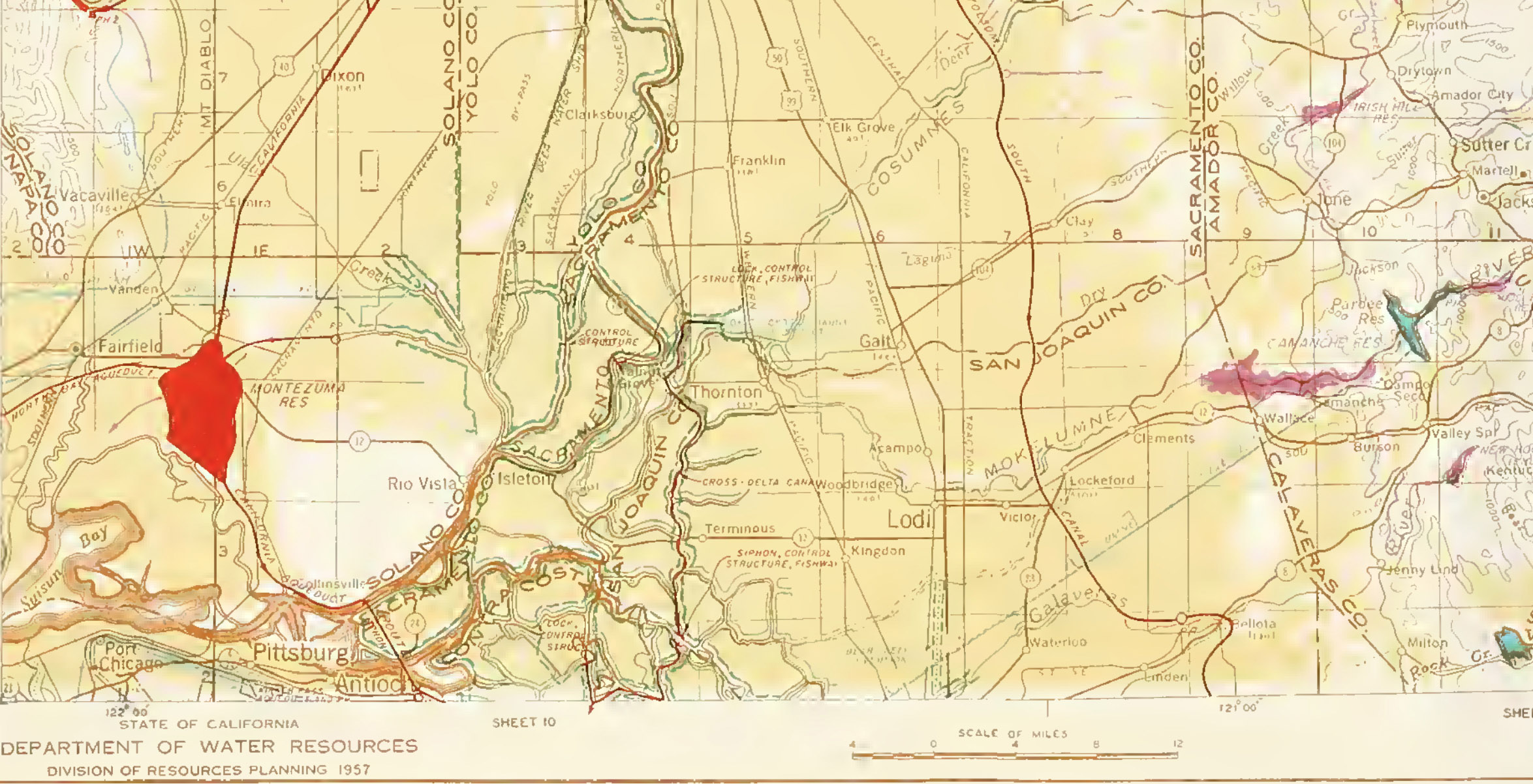
In the 1930 plan, that cut was to be made near Hood, pouring Sacramento water into a former backwater called Snodgrass Slough. The flow would follow this south to the Mokelumne River east of Walnut Grove, at the point where that stream loses identity in the maze of Delta channels. The southbound current would split here, following sloughs known as the north and south forks of the Mokelumne, to reach the San Joaquin River. Here the export waters would begin an upstream journey, via the San Joaquin itself and its distributaries Middle River and Old River, to the point of origin of these strands, near Mossdale Bridge in Lathrop. At this point a major pumping plant, the first of ten, would apply the suction needed to keep the artificial current flowing.
From Mossdale Bridge, the San Joaquin River channel would be remade into a staircase of pools behind seasonal, inflatable dams, each about ten feet higher than the next, with pumps lifting water against the normal direction of flow. This water escalator would continue for 72 miles, as far as the mouth of the Merced River. From there, a new aqueduct would carry water to the western side of the San Joaquin Valley.26
In addition, a Contra Costa Canal would carry potable water westward from Rock Slough in the western Delta to cities and industries for which the “offshore” water at Antioch, though supposedly kept fresh enough for agriculture, would become too salty.
This was the state of thinking when it became clear that the State of California was no longer in a position to finance so massive a set of works.
The federal Central Valley Project
The Legislature authorized what was already called the Central Valley Project in 1933. The Pacific Gas & Electric Company, opposed to the plan because it would put the government in the power generation business, forced a referendum, which the plan survived. But times were hard and the State did not even try to sell the projected $170 million in bonds. Instead it turned to Washington, D.C. for help, which gradually revealed itself to be a complete federal takeover. President Roosevelt gave the decisive order at the end of 1935. In the 1937 Rivers and Harbors Act, Congress made it official, reauthorizing the Central Valley Project as an undertaking of the U.S. Bureau of Reclamation.27
Even as the initial work proceeded, the plan was changing. Shasta Dam grew taller. Very significantly, the point at which export water would leave the Delta was shifted west, to the Old River northwest of Tracy. I have found no document describing the moment of this change. DWR staff believes that the site was chosen to further minimize competition with senior water rights holders, and also because it could accommodate a big power plant to serve the energy-hungry pumps. (Hydropower from Lakes Shasta and Folsom would in fact drive them.)28
The very last thing to be determined was the path the water would take from the Sacramento River southward toward the pumps.
In 1941, Senior Engineer H. R. McBirney traversed the route laid out in the State’s 1930 plan and reported to his boss: “One needs only to follow the river-and-slough route, as I did, to acquire a feeling that, after all, there must be some better location on which to build a channel.” For a moment, discussion centered on something very like the later Peripheral Canal. This option seemed too expensive, however, and promised to excite much local opposition.29
So a route based on existing channels would after all be chosen. The alternatives narrowed further until, in 1949, state and federal engineers held a sort of summit conference in Denver, where the Bureau had constructed a working model of the Delta. The upshot was that the Sacramento would be tapped at Walnut Grove. A 4,200 foot long Delta Cross Channel would link to the south end of Snodgrass Slough and, shortly, to the incoming Mokelumne River. Thence the augmented flow would follow the 1930 paths. Because of the shift in end point, however, the flows in some channels would be opposite the ones projected in the earlier plan.30
In 1953, well after the Tracy Pumping Plant had begun operation, the Delta Cross Channel carried its first water.31 Delta conveyance was now a reality.

Two less tangible innovations were also important. As a project of the Bureau of Reclamation, the new CVP was supposed to favor small farms by serving only properties of 160 acres or less; this was a source of lasting controversy. And, more importantly to the present story, the federal CVP quietly abandoned a key promise of the State plan: the repulsion of salt water from the Delta was no longer listed as a purpose, and the benchmark of maintaining any specified westward flow at Antioch was no longer mentioned. This change of expectation became general knowledge only in 1957.32
The southwestern location of the withdrawal point, however, replaced the written guarantee, at least in part, with a physical one. Under the new system, somewhat more of the export-bound water flowed in western channels. The Old and Middle Rivers became the all-important conduits. Water in these channels would have to be kept quite fresh for export via the pumps. The Contra Costa Canal, built now as a federal facility, also had its intake near the Old River corridor (on Rock Slough). Farmers in most of the Delta, at least, were thus guaranteed a usably fresh supply.
In a sense, in its choice of pump locale, federal decision-making had placed a hostage in the hands of those who wanted to maintain strong Delta outflow toward the west. In future decades, those interests would prove reluctant to give up that leverage.
Despite McBirney’s skepticism about “the river-and-slough route,” the initial facilities of the CVP seemed to function as advertised. The Delta Cross Channel and the chosen sloughs carried the required amounts of water, reasonably directly, to the federal pumps. Run full out, those pumps could move about 3.5 MAF a year, a volume that has never been reached.33
But, of course, no one ever regarded these facilities as a final stage. It was the attitude of planners at every level that the state’s rivers should be exploited for human use to an extent limited only by the brute constraints of hydrology, engineering, and finance. Much bigger ideas were indeed brewing, in both state and federal minds.
Sidetrack: The return of the barrier
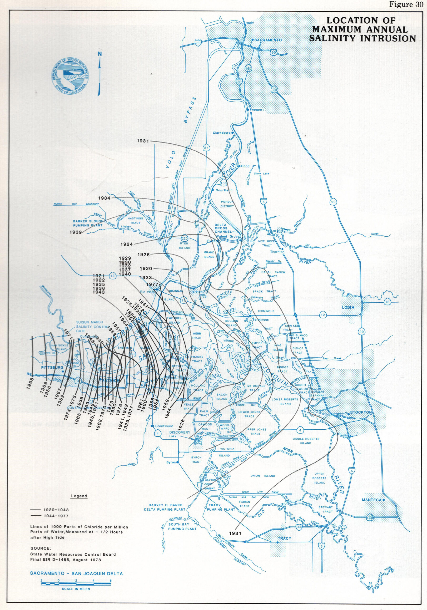
Though the idea of a salt water barrier was never again endorsed by top-level water planners, it had a long afterlife. There was continued drought in the 1930s, and in 1931 salinity intrusion reached a record. The one-part-per-thousand chloride line—the level at which water is useless for most irrigation—moved to a point between Courtland and Hood on the Sacramento and all the way to Stockton on the San Joaquin. There were additional salt pushes in 1934 and 1939.34
In 1932, the barrier plan resurfaced from an unexpected quarter. A man named John Reber, without relevant expertise but with very good contacts, expanded what began as an idea for an Oakland-San Francisco railroad crossing into a plan to build dams turning both San Pablo Bay and southern San Francisco Bay into freshwater lakes. Reber promised unlimited fresh water to all Bay-Delta users, and later talked up a canal to Southern California (anticipating nascent State ideas).35

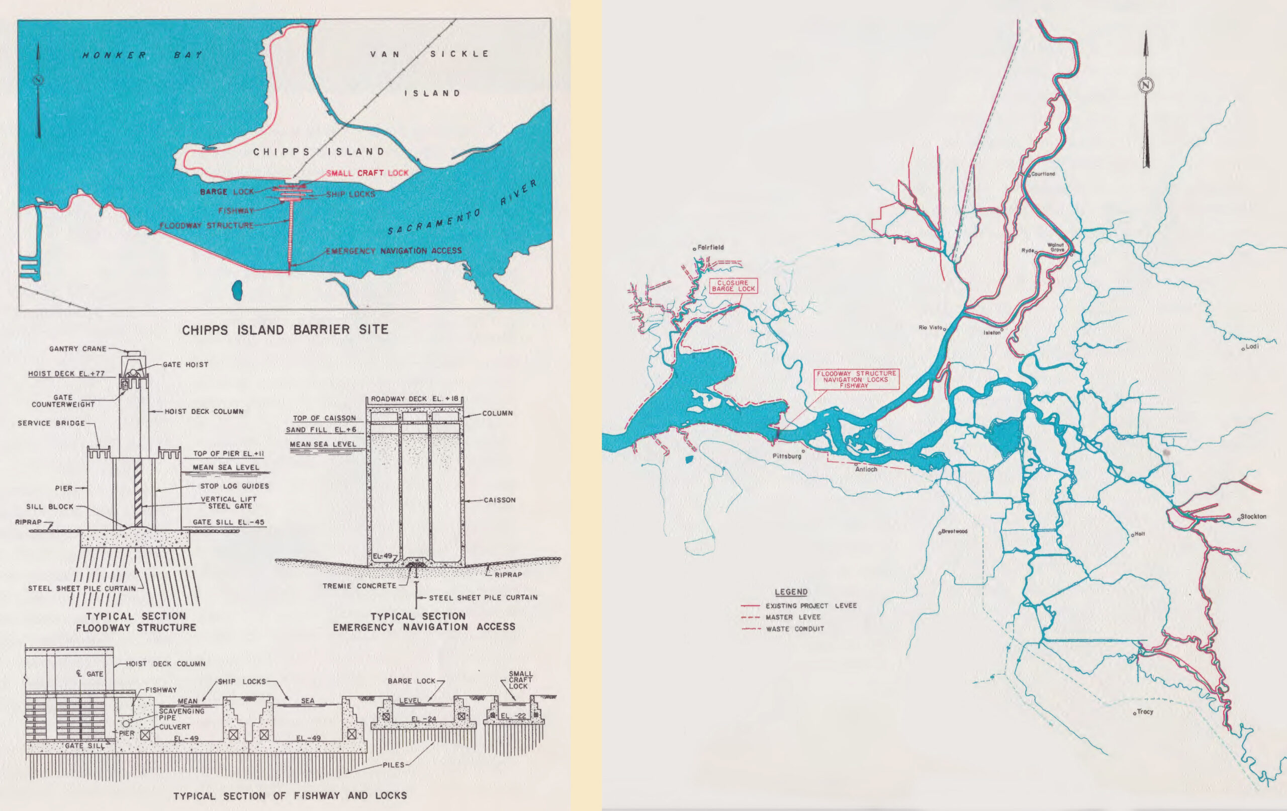
A tireless visionary, Reber attracted considerable political support. In 1952, Governor Earl Warren signed the Abshire-Kelly Salinity Control Act, starting what became six years of barrier plan studies. When these too yielded negative results, the advocates placed their hope in the Army Corps of Engineers, which seemed friendlier to barrier ideas. To test the hydraulics of such works, the Corps built the wonderful San Francisco Bay Model in Sausalito. On hand to celebrate its completion in 1957, Reber did not live to see the results it yielded in 1963: grandiose barrier plans were once again deemed impractical. In many years, the Corps found, the Reber lakes would actually fall below sea level, losing more water to evaporation than river inflows could replace.36
The Corps did advocate more study of barriers nearer the Delta, at Chipps Island or in the Carquinez Strait, but these never made it far up the list of options as water planning continued.
The federal plan of 1949
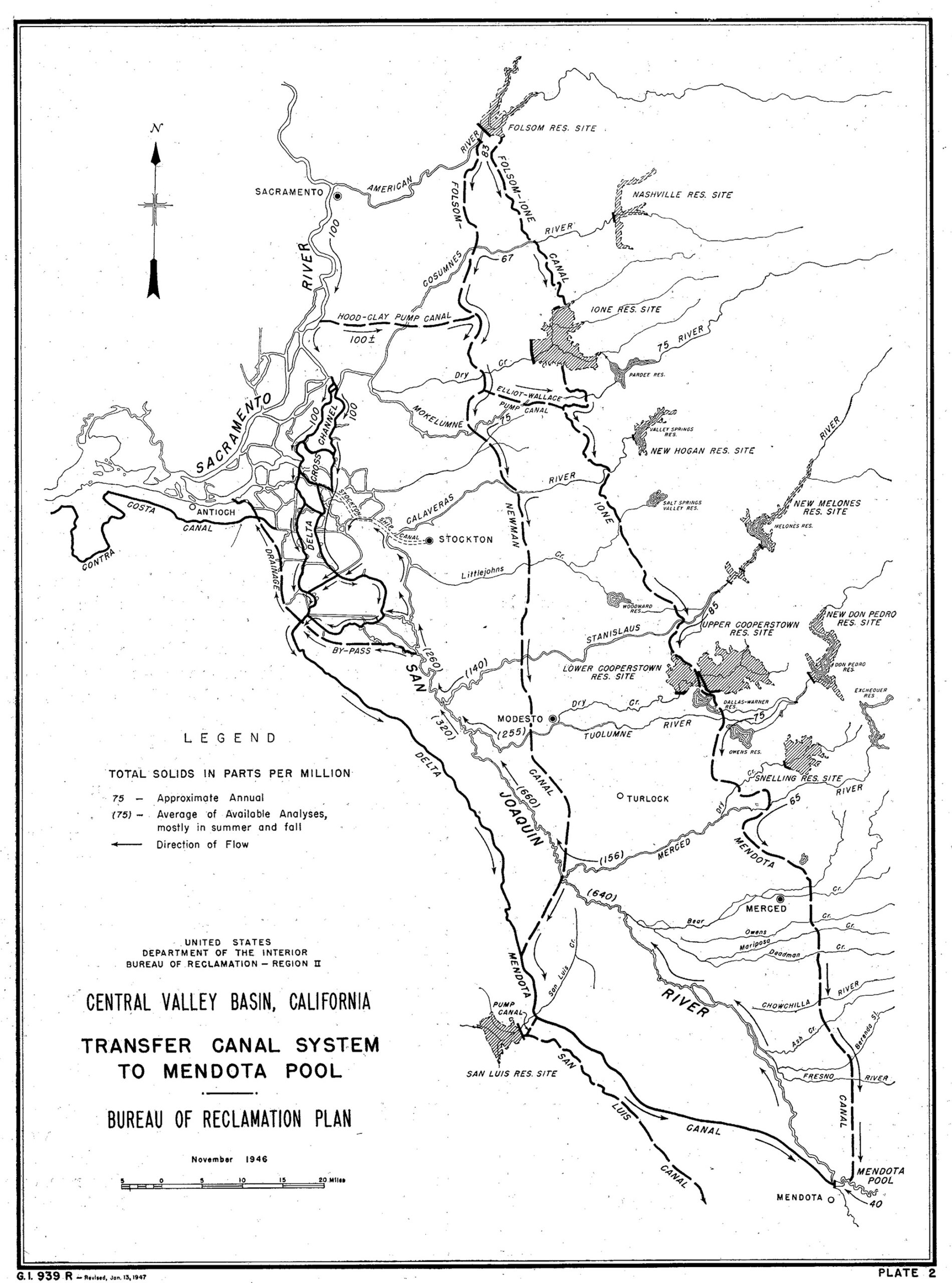
Having taken the lead in Central Valley water matters, the Bureau of Reclamation would have been very happy to keep it. In a massive report to Congress in 1949, titled Central Valley Basin, the Bureau laid out a plan for 38 major impoundments on tributary streams, including many that freckle the landscape today, but also such others as a Table Mountain Reservoir between Red Bluff and Redding (Marshall’s Iron Canyon), a Coloma Reservoir on the South Fork American River, and a new dam on Cache Creek.37
The Bureau intended to send much more water southward, but it did not want to route those exports through the Delta Cross Channel and the sloughs. Rather, it revisited Marshall’s old idea of a Delta bypass. A new canal would tap the Sacramento at Hood (we will get used to seeing this place name) and run east to join a north-south aqueduct running along the eastern foothills from the American River, past the Delta, to join the Delta-Mendota Canal near Gustine. The foothill line would also carry water from the planned Folsom Dam. At some future date, the Bureau foresaw a second foothills canal, at higher elevation, reaching from Folsom to the Mendota Pool.38
Feather River entering Lake Oroville. Photo: Kelly M. Grow, Cal Department of Water Resources
The State Water Project & Early Conveyance Visions
Though forced to give up one project, the State had never ceded the water development field. The Bulletin 25 plan of 1930 had been re-embraced by the Legislature in 1941.39 Ever since the economic emergency had eased, state interests had been hoping to buy back the CVP from the national government. This was very largely in hopes of ending the 160-acre limit. (The buyback idea was given up for good only in 1954.)40
In 1945, the Legislature created a State Water Resources Board (not to be confused with the later Water Resources Control Board) and launched a new round of planning. Another series of Bulletins began. Number 1, in 1951, reviewed data about the state’s water endowment.41 Number 2, in 1955, assessed future water requirements.42 Number 3, issued in 1957, was a whole new California Water Plan, a maximalist vision briefly discussed below.
The Feather River Project and the Biemond Plan
But the real energy was behind a (relatively) modest plan to tap the Sacramento Valley’s second-strongest river, the Feather. The force behind it was Arthur Edmonston, State Engineer from 1950 to 1955. In May 1951, he brought out the Report on Feasibility of Feather River Project and Sacramento-San Joaquin Delta Diversion Projects Proposed as Features of the California Water Plan. Most of the system we know was laid out: conservation of wet-season flows behind Oroville Dam; an array of new pumps just west of the CVP ones between Tracy and Byron; and a great aqueduct linking the Delta not only with the San Joaquin Valley but also with metropolitan southern California. Left undefined, and indeed unmentioned, was how water from the Feather, after traveling down the Sacramento, would make it across the Delta.43
At this point the Feather River studies acquired, as a sort of tributary stream, the legacy of John Reber’s vision. As noted above, Governor Warren had launched another barrier study, supervised (in order to sideline the skeptical Edmonston) by a Board of Consultants. In 1954, the board hired a Dutch engineer named Cornelius Biemond, Director of Water Supply for Metropolitan Amsterdam and a member of the commission overseeing the “reclamation” of the Zuyderzee. To the disappointment of true believers, Biemond joined the consensus in dismissing downstream barrier plans.44
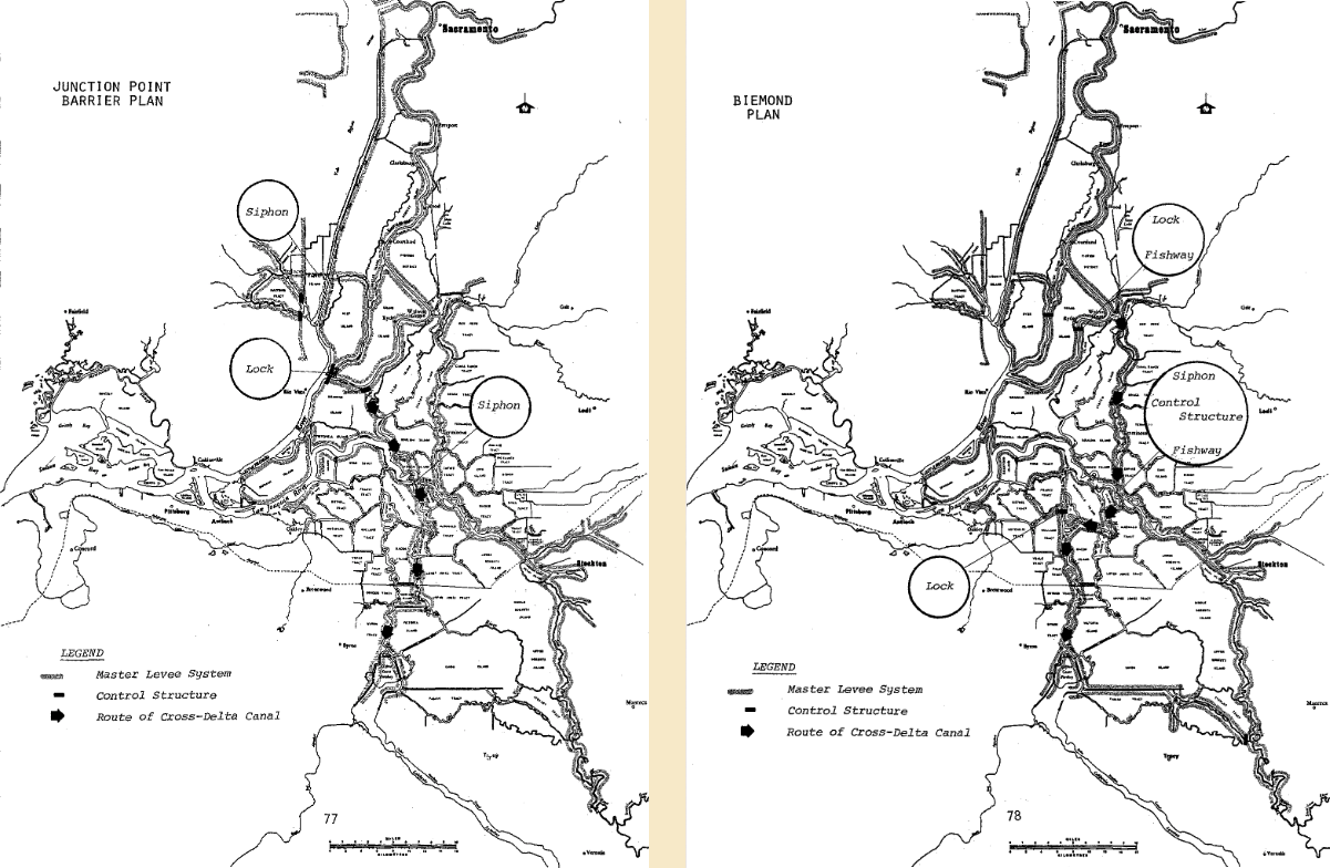
What the Dutchman proposed instead was in fact the remaining basic option for Delta conveyance. He called for creating an isolated water transport route by isolating selected waterways from the surrounding channel network.45 Control structures would be built on the Sacramento, and on its western offshoot Steamboat Slough, at points just north of Rio Vista. Water backed up behind these partial barriers would flow into a new cut made from the Sacramento near Isleton across a thin neck of Andrus Island to spill into Georgiana Slough and the Mokelumne River. Crossing the San Joaquin River by siphon, the flow would follow the Middle River south before making a final jog west to join the Old River and feed the pumps. The entire route would be “hydraulically isolated,” cut off by barriers from the rest of the Delta network. This plan was incorporated in the second major State Water Project report, Program for Financing and Constructing the Feather River Project, in 1955.46
Fantasyland: The California Water Plan of 1957
In 1956 the Legislature consolidated numerous agencies dealing with water matters into the Department of Water Resources, under whose flag appeared Bulletin No. 3, The California Water Plan. Assuming maximum need and unlimited budgets, this plan envisioned 370 reservoir and aqueduct projects. So sweeping was this vision that it featured a kind of buyer-beware note from its own Board of Engineering Consultants: it included “projects of doubtful economic justification and works of unproven physical feasibility.”47
In this pipe dream—pun inevitable—vast amounts of water would move across the Delta, by two routes. One would be a form of Biemond’s isolated channel. The second, to be built later, would be a downstream crossing: a siphon under the western tip of the Delta would carry water largely derived from the North Coast rivers and destined to serve the San Joaquin Valley and points south via a West Side Canal. Thus two conveyance concepts, through the Delta and around it, met in a single, double-barreled plan.48
Few of the notions in the 1957 California Water Plan survived in the many sequels that carry the same title. Nonetheless, water leaders asserted as late as 1984 that the original vision was sound.49
San Joaquin River near Old River and Franks Tract. Photo: Christina Sloop
Birth of the Peripheral Canal
While the 1957 Water Plan reposed on the shelf, the more tangible Feather River Project, now dubbed the State Water Project, continued its not-so-slow unfolding.
This is not the place to review in detail the steps by which this plan, or the first portion of it, was realized. In 1959, the Burns-Porter Act authorized a $1.75 billion bond issue, then a mind-boggling sum, for the first phase of construction. A companion piece of legislation, the Delta Protection Act, mollified one source of opposition by promising to keep western Delta waters fresh, or, alternatively, to bring a usable supply overland to farmers and other users. In 1960, the bonds passed narrowly, and work began. A couple of miles away from the federal pumping station on the Old River, the state erected its own battery of pumps, which began functioning in 1967.
Though specific about other waterworks, the Burns-Porter Act was vague about conveyance, listing “master levees, control structures, channel improvements, and appurtenant facilities for water conservation, water supply in the Delta, transfer of water across the Delta, flood and salinity control, and related functions.”50 So the water planners had unfinished business.
The Delta Cross Channel of 1951 and the sloughs it fed into were just about large enough to accommodate the Bureau’s needs. Now that a second straw was being stuck in the Delta, the additional flow induced by additional pumps would, by the laws of physics, find alternative routes. Some portion could pass through Georgiana Slough and Threemile Slough, but in dry years much would travel all the way down to the junction of the big rivers, at the western tip of Sherman Island, make a U turn, and head up the San Joaquin. Among other disadvantages, from an engineer’s point of view, was the fact that the channels around Sherman Island would all have to be kept full of fairly fresh water. More “carriage water” would have to come west to maintain the “hydraulic barrier” against salt. This water would continue on out toward the Golden Gate—in traditional thinking, a regrettable loss.
At the end of 1960, DWR made its first bid to fill in the missing link. This was Bulletin No. 76, Report to the California State Legislature on the Delta Water Facilities as an Integral Feature of the State Water Resources Development System. Though it gave the obligatory nod to the Chipps Island barrier, the report really concerned three versions of Biemond’s isolated, through-Delta conveyance. In each, the capacity of the Delta Cross Channel and CVP’s entire water route would be expanded. The Sacramento, San Joaquin, and Mokelumne would each get a “control structure” above which water would pool and rise in summer, letting gravity drive the southward movement. Certain communicating channels could be blocked. The engineers chose the simplest version, which they called the “Single Purpose Delta Water Project,” providing for an isolation less hermetic than in other variants.51
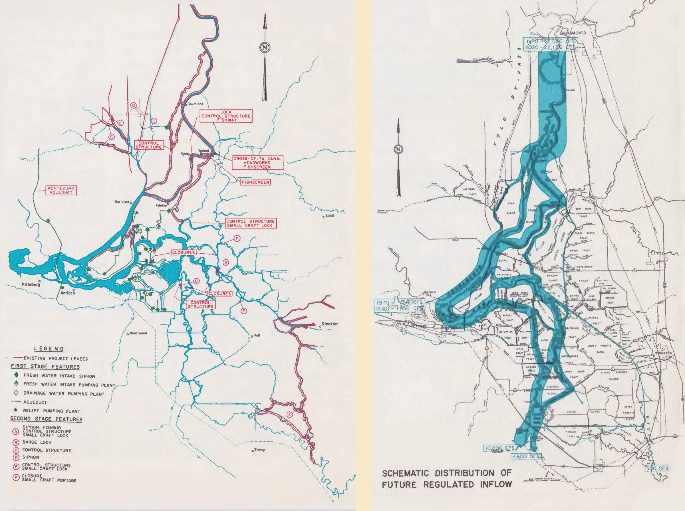
Once such a plan was carried out, the western Delta would no longer have to be kept fresh; the 1,000 ppm chloride line would move eastward to Decker Island on the Sacramento and the mouth of False River on the San Joaquin. Delta outflow would be reduced to 1,000 CFS at times.52 A new Montezuma Aqueduct would cross below Sherman Island to serve northern Contra Costa County, and a wastewater drain would carry polluted San Joaquin runoff around the Delta to Suisun Bay.53
During 1962 and 1963, hearings were held on this concept before the California Water Commission (another branch of the bureaucracy, with a mostly advisory role). Opposition was solid, especially from fishery interests and also from boaters, unwilling to have their movement curtailed by channel barriers. The plan went no further.54
But (as often in these matters) another negotiation was quietly proceeding. Within a month of releasing Bulletin 76, the Department had invited the Bureau and the Army Corps of Engineers to join in an Interagency Delta Study Committee (later just Interagency Delta Committee). The Bureau hung back at first, but when it engaged it brought forward a new/old idea that transformed the discussion: the very Peripheral Canal it had toyed with in the 1940s. The rebirth date can be placed on May 31, 1963, when a subcommittee reported: “The recent review of the advantages and disadvantages of the several approaches to solution of the Delta problem had indicated the need for an alternative that will give more consideration to fish and wildlife, recreation, water quality and public health.”55
The slow rise of environmental concern
Despite the later reputation of the Peripheral Canal idea, we should note that this was the first plan to be dictated in part by environmental considerations. For all earlier engineers, the waterscape was simply a problematic legacy, badly arranged in the light of human needs, to be reconfigured at will. Water not applied in farms, industry, and homes was water wasted. Other human needs, as for flood control and navigation, were the only competing concerns to be taken very seriously.
Pollution certainly was mentioned in the earlier barrier studies: without massive tidal flows to dilute inflowing wastes, would the water in barrier lakes be usable? (John Reber saw no difficulty: “Simply cure these man-made contamination elements, and you have absolutely pure water.”)56
Fish, too, and especially the commercially valuable salmon, figured in the early barrier reports. Fish ladders or passage facilities were called for, though at least one study questioned their practicality.57
The first more modern-sounding warnings were sounded by the Fish and Wildlife Service in comments incorporated in the Bureau of Reclamation’s massive 1949 volume Central Valley Basin. The chinook salmon run of 1944, the Service observed, had been the largest on record.58 “If dam construction proceeds without consideration for such a self-perpetuating, natural resource, the State and Nation as a whole will suffer a heavy irreplaceable loss.”59 Water moving across the Delta should be isolated from other flows. “Losses would also result from interference with normal migratory routes, confusion to fish caused by new directions of flow, and by mixing waters of different drainage basins” so that fish would have trouble homing in on their natal streams.60
The state had also weighed in, putting such concerns in their (very subsidiary) place. “If there is to be a conflict in the construction and operation of such works with the run of fish, such conflict should be anticipated sufficiently far in advance so that plans can be evolved for meeting the situation by adequate, feasible, and economic methods so that the fish may be protected as far as practicable and the main purpose of the project may not be defeated or materially hampered.”61
These dismissive comments were written in 1946. Fifteen years later, the concern for fish was more widely shared. In 1959, the Department of Fish and Game began collecting data on the condition of the population of striped bass, the prized sport fish. In 1961, DFG launched a broader Delta Fish and Wildlife Protection Study “to investigate the effects of future water development on fish and wildlife resources dependent upon the Sacramento-San Joaquin River estuary . . . and also to start us toward an understanding of the estuary’s ecology.”62 Even the very first results were disquieting. An estimated 15-30% of bass eggs were sucked into Central Valley Project Pumps and lost; this toll was expected to mount to 50-80% with the larger diversions everyone expected to come.63
The Peripheral Canal’s golden moment
So the Peripheral Canal entered the discussion as a new-look, sensitive, fish-friendly design.
The idea went public in September 1964 with the release of two documents, one thick and one thin, comparing options and firming up the choice of the Canal.64 The ditch would begin at Hood (of course) with a capacity of 18,300 cubic feet per second. The canal would skirt the Delta for 45 miles, passing under three rivers, Mokelumne, San Joaquin, and Old, via siphons. At the end the canal would fork to serve federal and state pumps. Clifton Court Tract, then an island, would be flooded to serve as a reservoir (forebay) to “smooth out fluctuations in pumping.” (This last idea, found sensible even without the canal, would be swiftly implemented.) Several options were discussed for supplying fresh water to western Delta agriculture. For one outcome was made very clear: Delta outflows would decrease, and salinity would advance.65

On November 6, 1964, a hearing was held before the California Water Commission. Only Contra Costa County (the Supervisors acting as the Contra Costa Water Agency) spoke firmly against the plan. Sportsmen were resoundingly in favor. The digest of comments reports: “An interesting aspect of the hearing was that, for the first time in our memory, large groups of fish and wildlife and recreation interests supported, almost without qualifications, a proposed water project. In fact, the entire San Francisco Bay fishing fleet declared a holiday so that the skippers and their families could be present at the hearing.”66 As the Interagency Delta Committee wrapped up its work, DWR Director John Warne wrote a colleague: “I am sanguine indeed that we are on the verge of achieving a solution to the complex water problems of the Delta.”67
1965-1982: Parallel tracks
Seventeen years would pass before the final verdict on the Peripheral Canal. That period saw two competing lines of development. One was continuing refinement of, and justification for, the plan. The second was increasing attention to, and a glimmering of understanding of, the biological role of Delta outflows—outflows that this conveyance improvement would surely reduce. The second process, which lagged behind the first, will be covered in more detail in another paper.
- In 1965, the Department and the Bureau reached an agreement, known as the November 19th Standards, on salinity levels to be maintained. As in all such specifications, these varied by location and by wetness or dryness of year. The essence, however, was that salinity would not be allowed to rise above 1,000 parts per million at Decker Island on the Sacramento and at a corresponding point on the San Joaquin. Holding this line would, it was thought, keep water in the vicinity of the pumps fresh enough for export. This would mean, it was then calculated, a flow of 1,500 CFS past Antioch at all times. (If these numbers sound familiar, they are the same levels foreseen in Bulletin No. 76 of 1960.) The agencies agreed that salinity could be allowed to move deeper into the Delta once conveyance had improved and replacement water had been provided for western Delta farmers.68
- In that same year, Congress passed the Water Pollution Control Act of 1965, addressed initially to interstate and coastal waters. Two questions arose: Did the law apply to the Delta, and was salinity a pollutant to be regulated? The answers (to shortcut a rather lengthy process) were Yes and Yes. From now on, pollution control rules would become conditions added to the two projects’ exercise of their water rights.69
- In 1966, the Department of Water Resources formally declared the Peripheral Canal to be the missing link in the State Water Project, authorized in advance, the State claimed, by the Burns-Porter Act. The Bureau, meanwhile, was hoping to secure a similar authorization from Congress.70
- In 1967, the DWR came to the Water Rights Board to seek confirmation of its right to divert water for the SWP. (It may seem backwards that this “permit” was sought after construction, but that’s the way these things worked back then and to some extent work now.) The result was Decision 1275, confirming the right on condition that the November 19th Standards (with slight relaxation) be followed.71
- In 1969, hearings on Delta water quality began before what had just become the State Water Resources Control Board (uniting the former pollution and water rights boards). The Contra Costa County Water Agency brought several scientists of note to question the state of knowledge about the Delta ecosystem and its flow needs.72 Meanwhile, Water Committees in the two houses of the Legislature endorsed the Canal.73 Governor Reagan, though no fan of big government projects, would soon add his Yes.74
- 1970 saw passage of the National Environmental Policy Act and the California Environmental Quality Act. These laws required agencies to study and disclose the likely environmental impacts of proposed decisions. Challenging the adequacy of these disclosures (federal Environmental Impact Statements and state Environmental Impact Reports) became a favorite tool of those opposed to government actions.
- In 1972, it began to seem that the Bureau would not in fact be able to help build the Peripheral Canal it had championed, though it might join in later. The State resolved to go it alone.75
- Also in 1972, the California Wild Rivers Act purported to place most of the North Coast rivers out of reach of additional dams (with a temporary moratorium for the Eel).76
- In that same year, the federal Clean Water Act, modeled largely on California’s Porter-Cologne Act of 1969, set the basic terms of modern American water pollution control. California became the first state to take responsibility for its own efforts under “delegation of authority,” subject to approval of the federal Environmental Protection Agency.
- In 1973, the Federal Highway Administration was set to start work on the stretch of Interstate 5 between Sacramento and Stockton, closely aligned with the planned canal. Following the advice of the Interagency Delta Committee, the fill needed for the raised roadway was to be pulled from borrow pits along the future waterway. Friends of the Earth sued in federal court, saying that the pits amounted to jump-starting the big ditch and should have triggered an environmental assessment of the canal as well as of the road. The challenge failed in the end, but caused some delay.77
- In 1973 as well, Congress passed the Endangered Species Act, which would eventually play a huge part in Delta affairs. (The State would pass its parallel law a decade later.)
- In 1974, the state published a DEIR, extremely cursory by later standards, on the canal. It foresaw benefits to fish. Western Delta salinities would rise with or without a canal. The document was silent on possible effects seaward from Suisun Marsh; it also assumed full cooperation by the federal project in managing flows and supporting fish, despite the fact that the Bureau of Reclamation was in court to deny the state any say over its operations. The statement noted that many effects depended on just how the canal was operated, but declined to explore how it might be operated: “Monitoring environmental conditions for modification of operation, together with flexibility for operation incorporated in the design of the facilities, will permit a wide enough range to adjust for these conditions.” This evasive-sounding statement actually reflects the reality of such projects: one cannot fix, or know in advance, what rules will govern their use.78
- In 1975, the new Jerry Brown Administration started a ground-up reappraisal, the Delta Alternatives Review Program. The following year, a Phase II Report appeared, exploring such options as a west Delta canal and a reservoir in the Montezuma Hills. Even the idea of shifting water diversions to a point west of Antioch was given a look. In the end, however, the familiar Peripheral Canal emerged unscathed.79
- In 1980, the Legislature passed SB 200, providing for the Peripheral Canal, relocation of the Contra Costa Canal intake, and many other potential reservoirs and facilities. Work on the canal would not begin, it provided, until DWR and the Department of Fish and Game had signed an agreement for ”the restoration and maintenance of adult populations of fish and wildlife at historical levels in the delta and the Suisun Marsh and the San Francisco Bay system. … The agreement shall include those limitations on exports and diversions to storage which are necessary to restoring and maintaining historical levels of fish and wildlife.” DFG and the Water Board were instructed to study outflow needs some more, without holding up the certification of a new Environmental Impact Report.80

- Trying to blunt one source of opposition, Brown pushed a Water Resources Development and Protection initiative, Proposition 8 on the November 1980 ballot. Approved by the voters, it added some Delta protections and somewhat strengthened the lock on the North Coast rivers, on one condition: it would all evaporate if the Peripheral Canal were not in fact begun.81
- At the beginning of 1981, at Brown’s urging, Interior Secretary Cecil Andrus placed these rivers, Eel now included, in the federal Wild and Scenic Rivers system, making designation very hard to revoke. This action weakened one argument for the Canal—that it would be needed to carry North Coast water—and one argument against—that its construction would make a new round of dam-building inevitable.82
These maneuvers did not mollify skeptical environmentalists so much as they galvanized opposition from farm interests that wanted something like a no-frills Biemond Plan, access to the undammed rivers, and less attention to fish. Two San Joaquin Valley firms, J. G. Boswell Company and Salyer Land Company, bankrolled conservation groups in an anti-canal alliance of convenience.83 Signatures were rapidly gathered to force what is called a veto referendum.
Election Day was June 8, 1982. The ballot arguments make one regret that so important an issue is being decided on so shallow a basis. There is no real discussion of the problems with existing conveyance, no raising of concerns about export levels and outflows. Rather the pro-canal side promises frictionless solutions it cannot deliver (and which are not really borne out in the text of SB 200). The anti-canal statements, on the other hand, fall back on capital letters and the fear of taxation: “FACT: Proposition 9 may cause PROPERTY TAXES to be RAISED beyond the levels established by Proposition 13.”84
On June 8, 1982, a convincing majority of the electorate voted No on the package. It had won in most Southern California counties by small margins, but lost in the north by huge ones. Post-election polling indicated that the sheer cost of the plan had in fact been the voters’ top concern.85
The aftermath
In retrospect, the 1982 vote signified much more than the abandonment of a canal. Together with wild rivers designation, it can be seen to mark the end of one era, a kind of closing of the wet Frontier. The seemingly endless vista of dams and water transfers had abruptly narrowed. It became clear to many (though not to some engineers) that the future was going to be one of coping with limits, making the most of a fixed or very slowly growing developed water supply.86
Of course improved Delta conveyance was part of that coping. It was unresolved as before.
In 1983, the Department was back with a pick-up-the-pieces study. In Alternatives for Delta Water Transfer, it laid out four options that could be described as crossbreeds of the Peripheral Canal and the Biemond Plan. Three of the options would supplement the Delta Cross Channel with a bigger canal beginning, as always, at Hood. From there on south, existing channels would be dredged and reinforced to handle larger flows. (A fourth option would work with existing channels only.) At the south, Clifton Court Forebay, the anteroom to the state pumps, would be modified to accept more water. The sloughs it draws from might be expanded, or replaced by a new stub canal angled east; or the Forebay itself might be enlarged.
One of the alternatives that didn’t make the final four was a slimmed down Peripheral Canal dubbed the East Delta Conveyance Channel, with about one third of the originally planned capacity. This facility would supplement, but not replace, the existing through-Delta route of the waters. Thus the “hydraulic barrier” against salt intrusion near the pumps would have to be maintained. This may have been the first appearance of the term “dual conveyance,” which would resurface in the era of the tunnels. In any case, the planners ruled out this variant in deference to “public opinion.”87
Governor George Deukmejian chose one of the simpler options and made an all-out effort to enact it as part of water package in 1984, with a repeat attempt in 1987. The thought was that a Biemond-like project, however unwelcome to Delta farmers and environmental groups, would please San Joaquin Valley agriculture and foreclose any new odd-couple coalition against the plan. But the “Duke’s Ditch” legislation did not pass.88
Harvey Banks Pumping Plant for the State Water Project. Photo: Ken James, Cal Department of Water Resources
The Problem that Won't Go Away
For the next fifteen years, conveyance receded from the headlines for a while, if hardly from the minds of water planners. The world did not stand still. The buildout of the State Water Project continued. More water moved southwards. Scientific knowledge grew, generally tending to underline the value of Delta outflows. The federal government brought increasing pressure on behalf of the environment, in several forms. And numerous Delta fish species went into enduring decline.
- In 1986, a long series of legal disputes about the powers of the State Water Resources Control Board came to an end. In May, State Appeals Court Judge John Racanelli ruled that the board did have the authorities it claimed, including over operations of the Central Valley Project.89 By year’s end, Department and the Bureau signed a Coordinated Operations Agreement, undertaking at last to manage their two systems as one.90
- In the same year, as planned, four additional pumps were added to the seven existing ones at the state’s Banks Pumping Plant, raising its export capacity to 10,920 CFS, or a theoretical 7.9 MAF a year. DWR and DFG signed a “4-Pumps Agreement” (later called the Delta Fish Agreement) to monitor fish losses and to offer mitigation to offset them, supposedly, “fish for fish.”91
- The fish, apparently, did not get the word. In 1989, the Sacramento River’s winter run of chinook salmon was listed as Threatened under the federal Endangered Species Act, the first in a long series of such designations. In 1993, the Delta smelt was federally listed as a Threatened species; the winter-run chinook was downgraded to Endangered, and thus subject to greater protection, the following year.
- At about this time, the Department of Water Resources solved the problem of supplying fresh water to the westernmost Delta Islands, Sherman and Twitchell, by buying most of the properties there.

The CALFED decade
Early in 1994, the federal Environmental Protection Agency, dissatisfied with the Water Board’s halting progress toward regulating flows under the Clean Water Act, exerted its long-latent authority, threatening to impose its own water quality standards. That shock was one catalyst of a new initiative. In June, state and federal agencies came together in a consortium called CALFED; in December, they signed a Bay-Delta Agreement calling for a new joint effort.92 “Peace has broken out,” Governor Wilson proclaimed.93 Henceforward, water supply reliability—a term left undefined—and the environment were to have equal priority. The hope was that big investments in marsh restoration and other habitat work would revive the ecosystem while also stabilizing or even increasing water exports. “Getting better together” was the slogan of the day.
In 2000, the CALFED apparatus produced what was called a Record of Decision but was really a roadmap for further work: seven years of more detailed planning, followed by 22 years of implementation.94 The conveyance issue was among the decisions saved for later. “The CALFED Agencies,” said the ROD, “will take all reasonable actions to optimize the use of the Delta as the means for conveyance of State and Federal project export water.” Old options were reviewed and some variants added. The ROD authors leaned toward a plan to add a new 4,000 CFS diversion at Hood, feeding south to the Mokelumne.95 (To jump ahead a bit, later study would find this idea unpromising.)96
CALFED started the new century bravely, but a loss of focus was soon apparent, first to insiders and then to the world. An impressive-sounding California Bay-Delta Authority was launched, but given little practical power. Federal support did not flow as hoped. By 2005, despite important progress in research and habitat restoration, the energy was gone.97
New urgencies
As CALFED limped into history, the Delta world was changing in alarming ways.
Beginning in the year 2000, biologists noted a further, steep decline in the numbers of several closely monitored fish species, including the delta smelt and the striped bass. By the end of 2004, the phenomenon had a name: pelagic organism decline.98
Another alarm had sounded. In June 2004, a levee west of Stockton broke, not in a flood time but on an unremarkable early summer day. The Jones Tract failure brought new attention to an old but underpublicized concern: the fundamental fragility of the Delta landscape. Since the region’s “reclamation” from marsh, peat soil oxidation had been hollowing out many islands. Many levees were substandard and deteriorating. In the long term if not in the short, these processes seemed to spell doom for some Delta islands. The loss of certain western tracts would completely disrupt the existing water export path.

At this point, Delta exports were about to reach the then-record level of 6.3 MAF.99 The latest CVP/SWP Operations Criteria and Plan proposed a further increase, while asserting that fish species would not be jeopardized thereby. A court challenge ensued. In 2007, a federal district court would order a reassessment that would lead, in due course, to the first really painful reductions in pumping rates.100 The Endangered Species Act had finally shown its teeth.
By this time, too, the effects of global warming had moved from prospect to dawning reality. One of those effects, sea level rise, promised to compound all other problems. It would increase the pressure on levees. It would raise salinity in channels feeding the pumps. Even without island failures, more and more “carrier water” would have to be released from reservoirs to keep the salt at bay.101 Eventually, the rising tide would bring an end to the existing method of Delta conveyance.
The search intensified for a magic formula that would protect recent levels of water export and salvage a declining ecosystem as well.
Once more unto the breach
2006 saw two attempts at a reboot. In April, water and wildlife agencies agreed to work together on a new Bay-Delta Conservation Plan (BDCP), attempting to wrap conveyance and endangered species protection into one grand package good for fifty years. In September, Governor Arnold Schwarzenegger created a Governor’s Blue Ribbon Delta Vision Task Force to grapple with the old knot of problems.
The Task Force inventoried the familiar conveyance options, and collected two more. The first, called Delta Corridors, was in essence another update of the Biemond Plan. The other was a kind of Biemond West using the Sacramento Deep Water Ship Channel as its main stem. Wrapping up its work in 2007, the Task Force picked no favorite but urged a decision within a year.102
The BDCP agencies, of course, were asking the same questions. The existential threat to the core of the Delta revived their interest in a route around the edge. “Time favors a Peripheral Canal,“ observed the Public Policy Institute of California in a 2008 study.103 Governor Schwarzenegger enthusiastically agreed.104 One difficulty was that the Canal’s intended route, once open land, was now partly urban. The DWR still owned property there, but the pits left by removing soil to elevate Interstate 5 had since become wetlands and, in a rich irony, subject to protection as habitat.105
From canal to tunnels
Even as the Governor renewed support for a canal, another idea was crystallizing. It arose, a DWR official told the press, from workshops held in the spring of 2009. “We had a lot of comments that said, ‘Why don’t you go under?’ So we thought we would take a look.”106 It seems more likely, though, that the idea had already emerged in intensive, ongoing studies.
Though many options were considered (and reconsidered) in the renewed planning process that followed, tunnels of various sizes were clearly top of mind. At the end of 2013, the plan was released, along with a 34,000 page EIR that independent scientists criticized as inadequate.107
The “preferred alternative” called for two identical tunnels, thirty-five miles long and forty feet in diameter, originating (it almost goes without saying) at Hood. Together they would have a capacity of 9,000 CFS, about 60% the size of the 1982 Peripheral Canal. Additional water could continue to move south via the Delta Cross Channel and the Mokelumne; this “dual conveyance” was offered as a reassurance that salinity must still be repelled. The agencies on the receiving end of the water, notably the Westlands Water District, the Kern County Water Agency, and the Metropolitan Water District of Southern California, would purportedly pay the costs. 108
In April of 2015, the comprehensive vision of the Bay-Delta Conservation Plan was abandoned, chiefly because federal agencies felt it impossible to sign off on a purported fifty-year solution for endangered species. The conservation element was scaled back and rechristened EcoRestore; the tunnels went forward as California WaterFix. A “Partially Recirculated” DEIR/DEIS ran the gauntlet of hearings and comment. DWR formally adopted the plan in July, 2017.109
Again the finish line seemed in sight—and again the momentum was fading. In fall of 2017, the Santa Clara Valley Water District announced that it was reducing its financial support, and Westlands Water District, a keystone backer, withdrew entirely. Though the Metropolitan Water District stepped in to fill the resulting funding void, damage was done, and an election was in sight.110 The end for the twin tunnels came with the voters’ choice of Gavin Newsom as Governor in November of 2018.
A (more) modest proposal
An alternative vision, first offered some years earlier, was already picking up support: a single tunnel, less expensive, and with a smaller, and thus perhaps less frightening, capacity. An alliance of conservation groups had included this concept in a 2013 package countering the Bay Delta Conservation Plan.111 The Public Policy Institute of California added its weight in a Sacramento Bee op ed piece near the end of 2016.112 Governor Newsom made the switch official upon his inauguration in 2019. The consultants re-converged. The planning machinery again began to hum again.
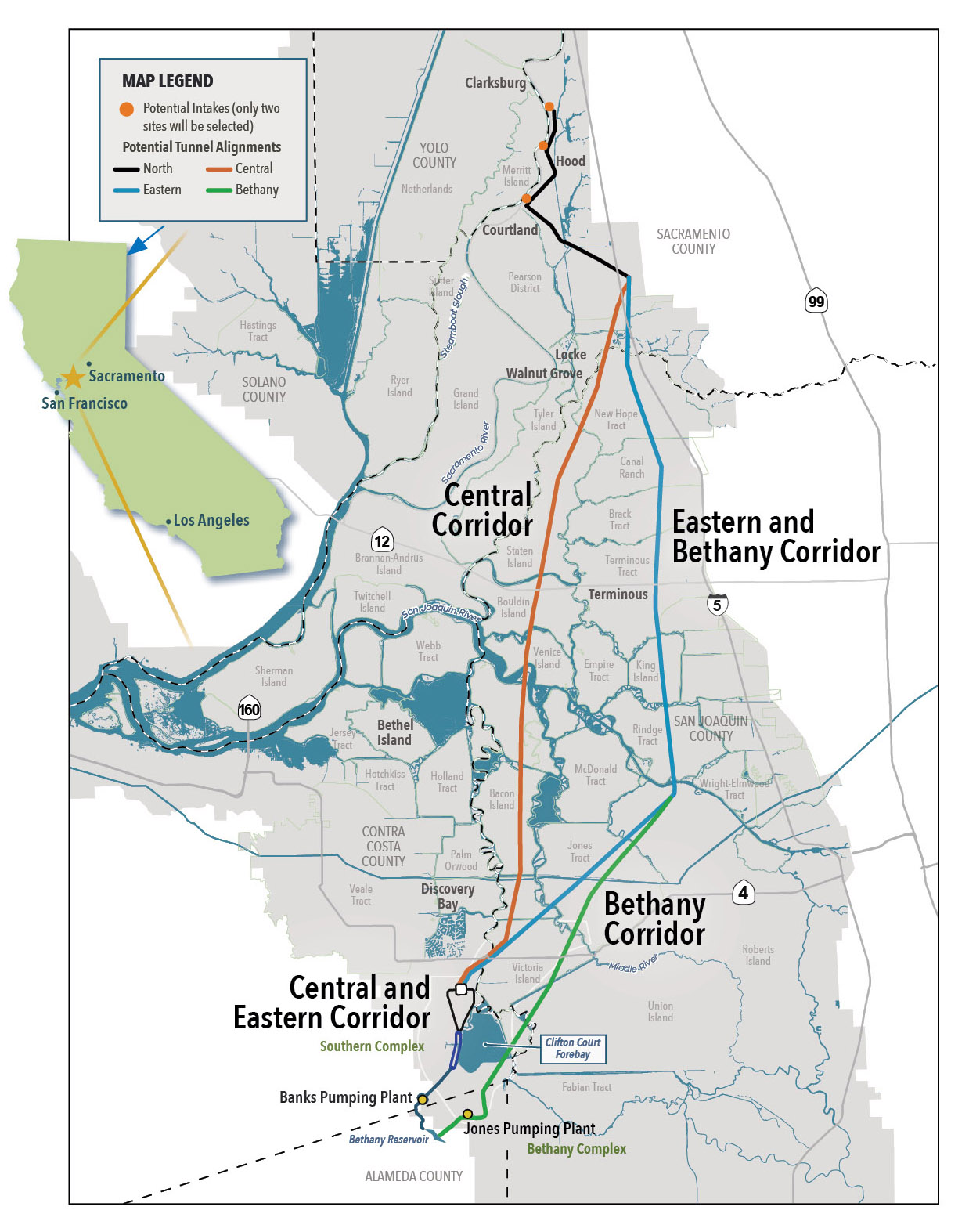
At this writing, the new DWR plan has just been formally released, with publication of a massive Draft Environmental Impact Report.The tunnel’s capacity is to be 6,000 CFS, two thirds the scale of the two-bore plan. The route is also changing: the preferred path lies east of the WaterFix line, nearer Interstate 5 and the old Canal alignment. It is hoped that construction here will be less disruptive to Delta communities. An aid package designed to meet certain Delta needs is also in the offing. But the most striking novelty in this conveyance plan is its end point. The tunnel will bypass Clifton Court Forebay and feed into the California Aqueduct at Bethany Reservoir, 260 feet above sea level and out of reach of any rising tide. Missing at this point is any direct connection to the Central Valley Project, including the Contra Costa Canal. This time around, the State Water Project is apparently going it alone.
As advertised, the new tunnel will be used in tandem with the existing conveyance route: “dual conveyance.” In fact, for the first decades, it will be the junior partner, carrying some 16% of export waters. The intakes at Hood will be opened only when environmental rules shut down the southern pumps and at times when the Sacramento is running high. This means that the old path, with its known disadvantages, will continue to dominate. The DEIR states that adding the tunnel will not harm fish (“less than significant impact”), but notably does not claim that the change will benefit endangered species. The two methods combined will permit exports, which have trailed off in recent years, to regain higher historic levels.113
This version of conveyance is indeed somewhat different from its predecessors. How it will be received remains to be seen.
The question of size, the question of trust
Environmental Impact Reports must look at alternatives, and the DEIR just released includes four, differing not only by alignment but also by capacity. In addition to the favored 6,000 CFS, it describes two smaller options, 3,000 CFS and 4,500 CFS, and one larger one, 7,500 CFS, which would tie into the Central Valley Project.
Arguments about conveyance have always been largely about scale. An upper limit is set by the combined capacity of the pumps near Tracy. Run full time—which is never the case—they could pull some 11 million acre-feet (MAF) per year. The Peripheral Canal could actually have delivered rather more than that.114 Since then, ambitions have shrunk. The twin tunnels could have handled 6.5 MAF per year, approximating the highest export levels on record. The emerging single-tunnel plan, at 6,000 CFS, would be capable of delivering some 4.3 MAF, still not far short of the recent export levels of state and federal projects combined.
The lowest number now under study, 3,000 CFS, has a history. A facility that size was proposed by the Contra Costa Water District in 2007 and endorsed by an environmental coalition in 2013.115 Such a tube would have a maximum yield of about 2.2 MAF. This would be essentially a cities-only plan, sufficient for the needs of the Bay Area and the Metropolitan Water District of Southern California, but not a great deal more.
There are pros and cons to any proposed conveyance scale. A very large channel gives water managers room to maneuver. In the Bay Delta Conservation Plan era, planners intoned “Big gulp, little sip”: minimal exports in lean years, big draws in fat ones. Operated this way, the big plan could make environmental sense. On the other hand, by loosening physical limits, any large facility puts the entire burden of salinity control and environmental protection on the shoulders of the operators and the regulators. Are those shoulders broad enough to carry the weight? As always, skeptics doubt that institutional restraints will stand up against the recurrent pressure for maximize deliveries, especially in drought.
The fear is not so much that rules will be broken (though arguably they have been at times), but that they will be kept weak, or weakened further, with all due legal form. It must be noted that, in dry years, current standards are quite irrelevant: in severe droughts they would require only one quarter the outflow that the water managers actually must actually maintain to keep salinity at bay.116 It is not reassuring that the Water Board’s latest update of water quality (and thus flow) standards is decades overdue.
The water agency world has its mirror-image fears: that, in the end, the structure will be too small, or regulations too severe. Will enough water move to justify the cost? Agricultural and urban districts may answer that question differently. Westlands Water District, whose withdrawal helped doom the twin tunnels, is not signing on for the single one, either.
Of course, any tunnel capacity can be supplemented, for some time, by continued use of the existing Delta Cross Channel pathway. With sea level rise, this “dual conveyance” will ultimately dwindle. At some point, the tunnel will be all the Delta conveyance there is.117
The climate change story does not end with rising tides. Another troubling question is beginning to be posed: can we count on enough water running out of the northern mountains to be worth exporting? The issue seems not to be precipitation—with all our dramas of drought and flood, that long-term average has held remarkably steady. Rather, it is the increased water demand by trees and other plants as temperatures inexorably rise. In terms of water available downstream, a foot of snow in the highlands is not what it used to be. The sad condition of our forests plays its part. Even without heat stress, too, the demands of senior water rights holders up and down the Sacramento River are likely to grow.118

Author’s concluding note
In writing this story, an old joke has often come to my mind. It’s the one where the stranger asks a local how to get to the train station. “If I were going to the station,” the native replies, “I wouldn’t start from here.”
To begin with conveyance is like reading (or writing) a lengthy novel from the middle. We don’t have Chapter One, concerning the state’s water endowment and the ways it is changing. We don’t have Chapter Two, which would probably have to concern our bizarre and dysfunctional water rights system. Chapters Three and Four would deal with ecosystem needs and shifting human water uses and demands. Chapter Five might be devoted to the Delta, its extraordinary landscape and people.
But this is my attempt at Chapter Six, as far as it has gone.
John Hart has been writing about California water issues since the 1970s. Among his books are San Francisco Bay: Portrait of an Estuary and Storm Over Mono: The Mono Lake Battle and the California Water Future, both from the University of California Press. Recognitions include two Medals in Californiana in the Commonwealth Club Book Awards, the David R. Brower Award for Outstanding Service in the Field of Conservation from the American Alpine Club, various others. Hart contributes regularly to Estuary News, Bay Nature, and KneeDeep Times.