Search Results for: Liu
Chapter F of Natural and Anthropogenic (Human-Made) Hexavalent Chromium, Cr(VI), in Groundwater near a Mapped Plume, Hinkley, California: Environmental Tracers of Groundwater Source, Age, and Geochemical Evolution
Documents in this series: Chapter A: Introduction to Study Area Hydrogeology, Chromium Sources, Site History, and Purpose of Study Chapter B: Survey of Chromium and Selected Element Concentrations in Rock, Alluvium, and Core Material Chapter C: Chromium in Minerals and Selected Aquifer Materials Chapter D: Analyses of Regulatory Water-Quality Data Chapter E: Groundwater Chemistry and … Continue reading “Chapter F of Natural and Anthropogenic (Human-Made) Hexavalent Chromium, Cr(VI), in Groundwater near a Mapped Plume, Hinkley, California: Environmental Tracers of Groundwater Source, Age, and Geochemical Evolution”
A Century of Delta Conveyance Plans
The Peripheral Canal. Duke’s Ditch. The Biemond Plan. Jerry Brown’s two tunnels. Gavin Newsom’s one. Sometimes it seems that California water debates revolve around a single question: how best to shift water from the Sacramento River, across, around or under the Sacramento-San Joaquin Delta, to farms and cities to the south and west.
Relative risk of groundwater-quality degradation near California (USA) oil fields estimated from 3H, 14C, and 4He
Relative risks of groundwater-quality degradation near selected California oil fields are estimated by examining spatial and temporal patterns in chemical and isotopic data in the context of groundwater-age categories defined by tritium and carbon-14. In the Coastal basins, western San Joaquin Valley (SJV), and eastern SJV; 82, 76, and 0% of samples are premodern (pre-1953 … Continue reading “Relative risk of groundwater-quality degradation near California (USA) oil fields estimated from 3H, 14C, and 4He”
DGMETA (Version 1): Dissolved Gas Modeling and Environmental Tracer Analysis Computer Program
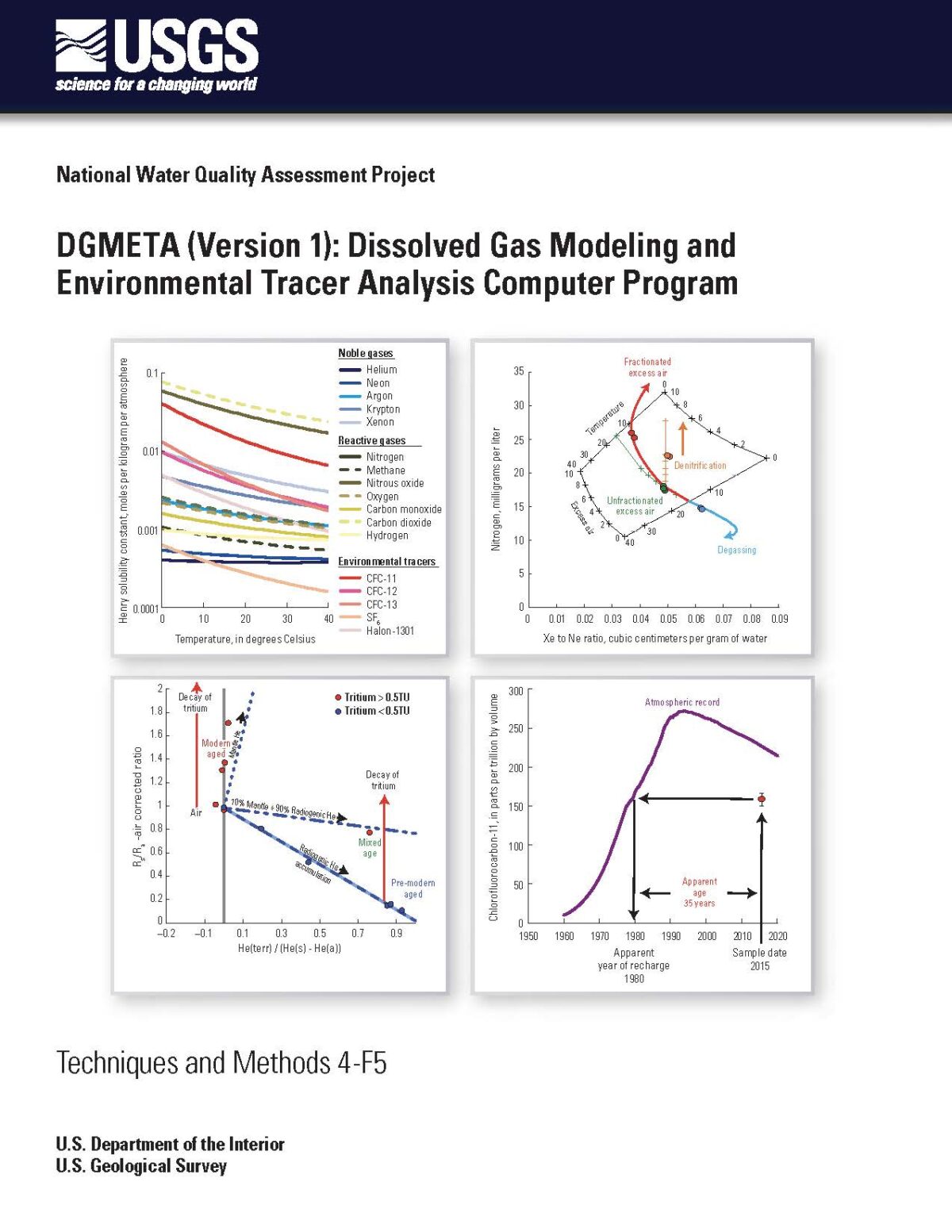
DGMETA (Dissolved Gas Modeling and Environmental Tracer Analysis) is a Microsoft Excel-based computer program that is used for modeling air-water equilibrium conditions from measurements of dissolved gases and for computing concentrations of environmental tracers that rely on air-water equilibrium model results. DGMETA can solve for the temperature, salinity, excess air, fractionation of gases, or pressure/elevation … Continue reading “DGMETA (Version 1): Dissolved Gas Modeling and Environmental Tracer Analysis Computer Program”
Time-lagged impacts of extreme, multi-year drought on tidal salt marsh plant invasion
Climate change is projected to increase the frequency of extreme drought events, which can have dramatic consequences for ecosystems. Extreme drought may interact with other stressors such as invasion by non-native species, yet little research has explored these dynamics. Here, we examine the physical mechanisms and temporal scale underlying a dieback of an invasive non-native plant, Lepidium latifolium, in … Continue reading “Time-lagged impacts of extreme, multi-year drought on tidal salt marsh plant invasion”
Updated Study Reporting Levels (SRLs) for Trace-Element Data Collected for the California Groundwater Ambient Monitoring and Assessment (GAMA) Program Priority Basin Project, October 2009–October 2018
Groundwater samples have been collected in California as part of statewide investigations of groundwater quality conducted by the U.S. Geological Survey for the Groundwater Ambient Monitoring and Assessment (GAMA) Priority Basin Project (PBP) since 2004. The GAMA-PBP is being conducted in cooperation with the California State Water Resources Control Board to assess and monitor the … Continue reading “Updated Study Reporting Levels (SRLs) for Trace-Element Data Collected for the California Groundwater Ambient Monitoring and Assessment (GAMA) Program Priority Basin Project, October 2009–October 2018”
Status and Understanding of Groundwater Quality in the Monterey Bay and Salinas Valley Basins, 2005: California GAMA Priority Basin Project
Groundwater quality in the approximately 1,000 square mile (2,590 km2) Monterey Bay and Salinas Valley Basins (MS) study unit was investigated as part of the Priority Basin Project of the Groundwater Ambient Monitoring and Assessment (GAMA) Program. The study unit is located in central California in Monterey, Santa Cruz, and San Luis Obispo Counties. The … Continue reading “Status and Understanding of Groundwater Quality in the Monterey Bay and Salinas Valley Basins, 2005: California GAMA Priority Basin Project”
Hydrogeologic Controls and Geochemical Indicators of Groundwater Movement in the Niles Cone and Southern East Bay Plain Groundwater Subbasins, Alameda County, California
Characterization of storage capacities and hydraulic properties of the complex aquifers and the structural and stratigraphic controls on groundwater movement aids in optimal storage and recovery of recharged water and provides information on the ability of aquifers shared by different water management agencies to fulfill competing storage and extraction demands.